
The surveying altitude of a project might easily be underestimated in its importance among surveying parameters. Evaluating the optimal flight level has direct influence on both the data itself as well as the cost of acquiring the data.
Definition
As with everything in aviation there is a variety of ways altitude can be defined. Related to aerial survey though, two definitions of altitude are common:
- Altitude above mean sea level (AMSL): Distance between the aircraft and a (historic) mean sea level. Pilots commonly calibrate their altitude indicator before take-off so that they show the altitude above mean sea level in the area they are operating.
- Altitude above ground level (AGL): Height measured with respect to the ground underneath the aircraft. Aircrafts equipped with radar altimeter allow the pilot to read the distance to the ground. Using the same measurement principle, some laser scanner also show this altitude above ground to the pilot by using the measurement value obtained in nadir direction of the aircraft.
While most of the flights are executed on a fixed altitude above mean sea level, the altitude above ground actually influences the data measurements and thus the resulting point cloud.
Acquisition geometry
When combining the survey altitude with the field-of-view chosen, an acquisition triangle spans up defining the coverages of the survey on the ground. Adding the forward motion of the aircraft the coverage expands into a strip (or swath). With a constant field-of-view, a lower survey altitude will result in a smaller swath width while flying higher will in contrast increase the coverage.
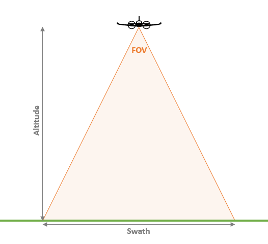
To increase efficiency of a survey, we want to increase the coverage rate as much as possible. This can either be done by widening the swath (fly higher or increase field-of-view) or by flying faster.
Effects on the resulting point cloud
Besides affecting the acquisition geometry, changing the altitude above ground also has direct impact on the spacing between the scanned points. Increasing the flying altitude will widen the swath and therefore spread the points across the swath, unless other survey parameters are adjusted. By increasing the spacing between points the resulting point density will subsequently decrease.
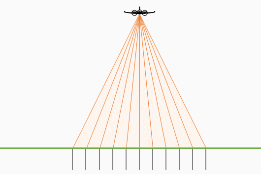
With increasing distances from the ground, the laser pulse signal generated by the sensor will have to travel farther as well. Subsequently the signal beam itself will also spread continuously according to it’s beam divergence, growing the footprint that the laser illuminates on the ground.
Limiting factors
While it would be nice to have complete freedom of setting the operating altitude, various factors have to be kept in mind:
- Signal strength: A laser pulse looses energy the longer it travels. With increasing flying altitude the returning pulse therefore gets much weaker, making it difficult to distinguish the peak return from general noise returns. Lowering the Pulse Repetition Frequency can help to increase the power output per signal, thus also improving the strength of the returning pulse.
- MTA zone: Depending on the survey settings chosen, the resulting measurement window will define how high you can fly to acquire good data.
- Terrain variation: Hilly areas and mountains will cause the swath width to shrink. In such areas, the surveying altitude is set to ensure that at least a minimum overlap is given at the highest point within the strip. (Alternatively, terrain following surveys or adjusting/splitting flight lines can help as well)
- Aircraft and/or sensor limitations: Various performance parameter by both aircraft and sensor will limit the range of possible surveying altitudes. Maximum flying or operating altitudes, aircraft speed, climbing rate, engine performance and similar all impact what at what altitudes a survey can be executed.
- Oxygen supply: After climbing to roughly 10’000ft with an unpressurized aircraft, pilots have to use oxygen masks due to the thin air at these altitudes. The oxygen consumed is aviation oxygen, which might not be available in the project country. Medical oxygen will freeze at such high altitudes and is not save to use for such purpose.
- Air traffic regulations: Aviation restrictions (civil or military) will always directly impact survey flights. For some areas special permits can be obtained, other areas might just be not possible to acquire.
Summary
Picking the right surveying altitude is what will define both efficiency and the resulting acquisition cost of your projects. Unfortunately setting this parameter requires consideration of many other factors. Knowing these factors and how they interact with each other is crucial for optimizing them for best performance. I hope this short overview gives a small insight into this challenge that aerial survey companies face on a daily basis.