
It is the year 2015, drones and robots are dominating our world… what reads like a science fiction novel could well be true as well for this year’s INTERGEO. UAVs were definitely omnipresent and it is hard to negate their uprising in the field of surveying.
Sensors for UAV platform
After having seen first drones enter the scene during last year’s INTERGEO, this year’s fair was flooded with companies developing or reselling remotely controlled vehicles. From small entry-level drones to full-scale fuel-powered mini helicopters, everything could be found among the booths. Realizing that writing about all these platforms would probably require its own blog post, I want to focus more of what was presented to be used as a payload…
Last year, Riegl’s VUX-1 and Velodyne’s PUCK certainly stirred up the market and got a lot of attention. This year, the same sensors, which are well suitable for use from a medium-sized UAVs, could be seen inside many of the presented integrated surveying solutions.
Bathymetry from UAV
At this year’s INTERGEO more survey-grade sensors were presented. Riegl introduced the first water penetrating LiDAR system to be used on their RiCOPTER platform. With a maximum swath width of 8.4m it is more designed for generating profiles of water bodies than full-scale bathymetric surveys.
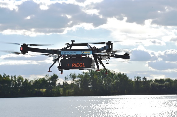
Riegl’s new BathyCopter
Survey Grade Hyperspectral Sensors
Probably the most common payloads for UAVs are passive sensors. Any camera from GoPro’s to mid-range digital cameras have been strapped to this platform in order to collect aerial imagery. Combined with super user-friendly software, every amateur drone pilot is now able to produce orthophotos for small survey areas.
Likewise passive spectral sensors have been used for collecting data beyond the visual range. Using information from near-infrared and other bands allows further analysis which supports the decision making of key stakeholders (i.e. in precision agriculture). While such light-weight multi-spectral sensors have been around a while, Specim now announced their range professional quality hyperspectral sensors suitable for use with remotely piloted aerial platforms. The newly introduced AisaKESTREL sensors allow to collect data with a GSD of 5-10cm.
Compact LiDAR Sensors
LiDAR on-board UAVs is one of the fastest growing segment of the survey industry. Besides the before mentioned sensors from Riegl and Velodyne, the ultralight all-in-one LiDAR system developed by Yellowscan definitely got some attention during this year’s INTERGEO. Already ahead of the trade fair Carbomap gave us a glimpse of the data collected during one of their forestry projects. If the tweet below is not enough to give you an impression, also check their blog post (or their online visualization) to see what kind of data such a compact LiDAR scanner is capable to produce.
@Carbomap is so impressed by the amount of details in the canopy of the @YellowScan data… pic.twitter.com/fLvdrLAO9e
— Antoine (@adanola) August 5, 2015
- Riegl Debuts BathyCopter at Intergeo
- Specim Releases First Professional Quality Hyperspectral Sensor Range AisaKESTREL for UAV’s
- YellowScan announces their latest all-in-one LiDAR unit
Truly Mobile Mapping
How mobile is mobile mapping? Most people would probably think about the car-mounted mapping system. We have seen them in the past – both LiDAR and image-based – and also this year there has been new announcements by the major system manufacturers. These systems have gained popularity during the past years and are now commonly used to collect data from within the urban canyons of buildings as well as street infrastructure.
Road mapping was certainly the pioneer among mobile applications. The trunk of the car conveniently provided space to accommodate all the required computers for data collection. Recent developments towards more compact sensors now eliminate this requirement, thus allowing for some truly mobile applications. We can now see these sensors attached to almost any platform imaginable. Rail-based platforms were just the obvious iteration from previous car systems. At this year’s INTERGEO we saw active scanners on push-trolleys, remote controlled cars and even backpacks. While these might currently still be in their beginning phases, future indoor mapping could well increase the demand for such systems.
- Streetmapper IV launched at INTERGEO
- Teledyne Optech announces Lynx SG-S Mobile Surveying Solution
- Faro releases new handheld 3D laser scanner
Summary
INTERGEO for sure is one of the most important meeting points for the geospatial community. With a growing international audience, INTERGEO has also become a place to announce new products and technologies which allows to identify future trends.
In the past – and also at this INTERGEO – we have seen continuous improvements for large survey sensors. Cameras, LiDAR sensors and other equipment have developed toward faster and more cost-efficient data collection.
Looking at the newly developed compact sensors, there is certainly a tendency towards more mobile applications. The combination with user-friendly processing software will soon allow the average person to collect and process geospatial data on their own.
The current trend is towards large-scale data collection with frequent local updates.
Are UAV’s replacing the aerial survey business? Certainly not – but the trend I see is more towards large-scale data collection which is updated more frequently by means of UAV or smaller sensors.
Maybe I’m wrong? How do YOU see the current trends? Let me know in the comments below…